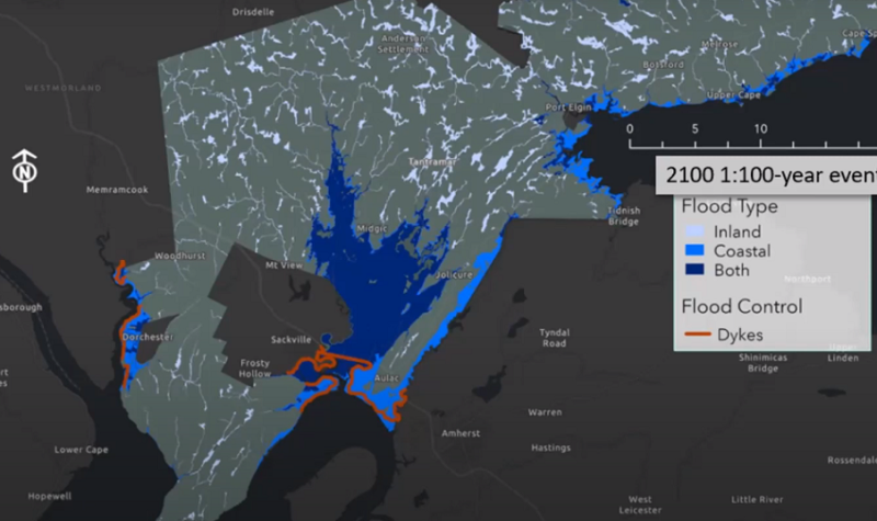
EOS Eco-Energy and the Southeast Regional Service Commission (SRSC) painted a soggy future for Local Service Districts in the Tantramar region.
The region, already prone to flooding due to its proximity to the Bay of Fundy and the Northumberland Strait, will continue to grow wetter by the year 2100.
Sea levels are expected to rise up to a meter by 2100, which threatens homes and infrastructure in the area.
As of 2010, 233 buildings were in a flood risk area, but by 2100 that number will grow to 815.
Geomatics Manager James Bornemann and Chloe Berezowski (SRSC) co-presented their research “Exploring Flood Risk and Vulnerability in Tantramar Local Service Districts” over Zoom on Feb. 2.
“The Tantramar is particularly sensitive to changes in sea level rise…Over the past 100 years, sea levels have risen about 20 to 30 centimeters in the area, and they could rise to upwards of one meter or more by the year 2100," Bornemann says.
“These changes,” he says, “are projected to increase the flood risk considerably in the low lying areas," he adds.
Not all hope is lost, however, as the Tantramar has an invaluable resource that works as a natural protectant against floods.
The wetlands act as a sort of natural rain barrel or a sponge, which releases rainwater slowly rather than all at once.
The Southeast Regional Service Commission is launching a website soon that will contain all of their findings, maps, and tips about preparing a home for flooding.
The site also has a survey that Bornemann hopes Tantramar residents will fill out.
Flooding events on private properties or specific areas are sometimes hard to log, and Bornemann is counting on residents to help catalogue these events.
Bornemann and Berezowski’s full presentation is available on EOS Eco-Energy’s YouTube page.
As reported on the Tantramar Report:


