
Cortes Island is in the midst of a Level 4 drought.
There have been worse dry periods in the instrumental records, much worse according to a University of Victoria study of tree ring data, and most likely more severe droughts in the years to come.
“Summer is very typically a very dry time of year for the Island, as well as for the Gulf Islands. The problem is that because we didn’t get the Spring rains, we’re starting at a level that is lower than what it would be within a typical year,” said Ashlee Jollymore, a Hydrologist with the Water Management Branch in Victoria
Shallow wells
Some of Cortes Island’s shallow well owners are approaching a critical point.
John Preston describes the situation in terms of the Island’s aquifer.
“When we moved to Cortes Island, 18 years ago, a dear architect friend who looked over this property for us said, ‘you will need water.”
“I said, ‘okay. we’ll drill a well.’”
“He said, ‘Please do not drill a well. Have a high quality surface well. Every well we drill now ultimately weakens our long term water aspect.’”
Preston agreed and now has a 27’ deep surface well, but the water situation appears to be worsening.
The marshland above his property used to remain swamp all year round; now it is dry during the summer.
Preston has been dealing with water shortages every summer for the past five years. This is the worst. The water shortages he usually deals with in late August is already here.
“We are four weeks early in our water deprivation and there is a chance our water deprivation will go longer into the Fall than usual,” he said. “We may have to close down our business.”
He has two choices: drilling a well (and hope the aquifer won’t fail) or moving to a rainwater catchment system.

Schematic of an aquifer showing confined zones, groundwater travel times, a spring and a well from US Geological circular via Wikipedia (Public Domain).
Rainwater catchment
His friends Kristen Schofield-Sweet and John Shook have been dependent on a catchment system for 31 years.
“Of course at that time, we didn’t know about climate change or that rainwater would become an issue. We are, if anything, more pleased now that we have that system, rather than feeling anxious and alarmed that somehow we’ve misjudged and are going to run out of water,” said Schofield Sweet.
One of their small concrete cisterns is dry and the water level is low in the second, but their big 3,000 gallon cistern is untouched.
The cisterns were partially dug into the earth, which means the water is always cold. As the system is gravity fed, it is also impervious to power shortages. It supplies all of their needs except drinking water, which they obtain at the Gorge Marina.
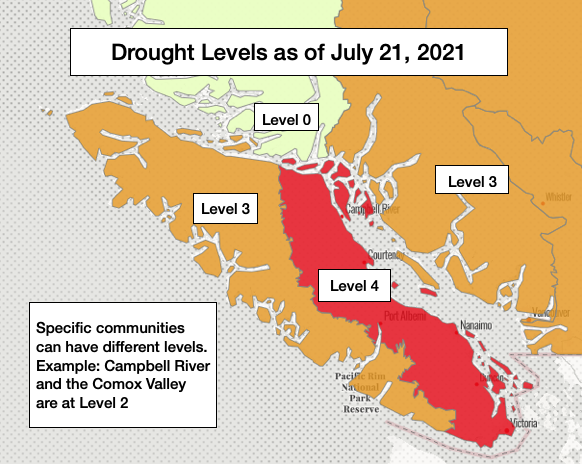
Though most of eastern Vancouver Island is now at drought Level 4, there are places where it is only Level 2.
Campbell River is among them.
“Campbell River is sort of a [challenge] to assign because a lot of it is fed by a big lake or it is regulated," as Hydrologist Ashlee Jollymore explained. "The John Hart Dam is on that system. So it is a really tough one to say how dry it is because a lot of those levels are not natural, they are regulated by that dam system. The one that we do look at is the Oyster River, a little bit further to the south, that’s just unregulated flows. And is at Level 4.”

BC's Drought Levels. Graph by Roy L Hales, adapted from appendix 1, British Columbia Drought and Water Scarcity Response Plan.
Climate change
Vancouver Island has gone through drier periods in the past. The worst droughts in the historical record set the bar for drought Level 5. However, the climate is changing, so CKTZ news asked Jollymore what can we expect in the future.
She described the projections for precipitation as a really tough challenge, both in the short term and over longer periods of time.
“What climate change scientists are telling us is that instances of precipitation could be more chaotic in the future … We may get the same amount of rain, but it could come as a few storms as opposed to smaller storms over a longer period of time. Just to say, the projections for precipitation come with a lot of uncertainty relative to the projections for, say temperature,” said Jollymore.
The latest drought levels on Vancouver Island. Map adapted from Drought Levels Map at the BC Drought Information Portal by Roy L Hales
The Mega-drought theory
A few years ago, a University of Victoria study of tree ring data found that BC has gone through 16 droughts exceeding anything in the more recent instrumental record.
One of the study’s co-authors, Dr. Bethany Coulthard, believes we are underestimating the potential impact of a mega-drought.
“When you look at how severe droughts can get and then you add climate change and land use change on top of that, it would be reasonable to expect that when one of these extreme events does happen it will be more severe than anything that has happened in the past 350 years. We will almost certainly experience droughts worse than last year in the decades to come," she explained in the study.
Jollymore was familiar with the study.
“I think when we get into the mega-drought situation, what we’re really looking at is multi-year precipitation deficit. So multiple years in which we don’t get the rain, or the snowpack in the areas that need a snowpack, and that persists over a long period of time,” she said.
“If those precipitation deficits continue to persist over the winter, into next year and the year after – that’s when I think those mega-drought definitions kick in. Hopefully we don’t get there.”
This may be happening in California, but not yet in British Columbia, she added.

Tree ring samples. Photo courtesy Dr. Bethany Coulthard.