Some Crystal Bay community members are upset about a lack of consultation regarding the delineation of a public waterfront.
An access point on Nesbitt Street, which opens into Nesbitt Creek, has been a cause for concern for community members who've complained about a lack of accessibility due to overgrown shrubbery, and an encroachment owned by a neighbouring property.
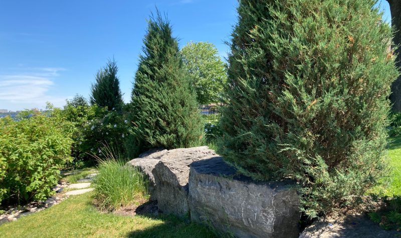
An encroachment is a structure or landscape feature built into a residence by private owners which crosses the public property lines.The encroachment in question, a stone wall which borders 2 Nesbitt St., was built by the previous owners of the property. The encroachment, along with the overgrown foliage obscuring signage and property markers, created confusion for residents who weren’t sure if they were allowed to access the waterfront.
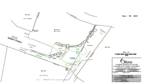
According to an online information session hosted by Bay Ward Councillor Theresa Kavanagh and City Coordinator Laureen Dinardo on Tuesday, the City of Ottawa is addressing the problem by installing an additional fourth bollard to better distinguish the property delineations. They have also signed an agreement with the owners of 2 Nesbitt St. to maintain the area where the encroachment is built.

The rock wall encroachment takes up about 25 per cent of the public space, according to Trudy Hall. Photo by the City of Ottawa.
Members of the community were invited to participate in the information session, but they were not allowed to make statements, and questions were posed in text format and read aloud by the hosts, without the opportunity for follow-ups.
Kavanagh and Dinardo say the community was consulted about the decision, but the president of the Crystal Bay Community Association, Trudy Hall, insists there was no consultation.
“The whole thing seemed flawed from our point of view, because there really was no consultation,” says Hall.
According to Hall, the community had raised their concerns on numerous occasions before the city requested to visit the site. Hall says the community association wanted to have an “all-inclusive, consultative” meeting between members of the community and their councillor, but agreed to the site visit in order to move the process along.
Hall says the city made its decision during the on-site visit, during which community members identified ideal places for property markers. But she doesn’t view that as adequate consultation. She says the community’s concerns with the decision were essentially dismissed during Tuesday’s info session.
“No consultation was intended there,” says Hall. “We were there to present those points, and not get pulled into any kind of argument, because we felt that we wanted more consultation with the community as a whole. ...But instead it turned out to be, ‘This is our decision. This is our rationale.’ All of the questions were really answered from the point of view of, ‘this decision has been made.’ And so people were not heard, and people were not consulted in this manner. So that's how we saw this process.”
There have also been concerns raised about the accessibility of the pathway leading to the waterfront, as Hall says it is obscured.
Currently, there is signage indicating the waterfront is publicly accessible. There are also three bollards indicating the boundaries of the property. Community members say that these aren’t visible from the road or sidewalk, as they have been obscured by overgrown foliage.
The city is responsible for the maintenance of public green spaces, and they call their jurisdiction over these areas their “Right-of-Way.” The encroachment at 2 Nesbitt St. is part of a private residence, and it’s the responsibility of the owner to maintain it.
Hall says the encroachment, which bears a “private property” sign, makes the area look uninviting.
“The residents are requesting that the encroachment on the area be more accessible, and more usable, we want to be able to use it,” says Hall. “And really, it's covered by large overgrown thorny shrubs, and spiky evergreens. It really looks like private property, and it's been landscaped, and so you don't feel that you can use it. And even if you do, it's hard to use it because it's full of hostile plants.”
Hall says that depending on where the water line is, the encroachment can take up around 25 per cent of the public area.
In Tuesday’s information session, Dinardo said that the rock wall encroachment doesn’t prevent the public from accessing the area.
“The subject rock wall and landscape features are established,” says Dinardo. “They’ve been there for almost 20 years. [They] don’t impede the public’s use of the water access in this location, which is key to the Water Access Strategy.”
The Water Access Strategy, passed in 2006, is a plan that added 326 publicly accessible waterfronts in the Ottawa area, the rationale being that access to waterfronts is essential to the mental health and quality of life of residents.
Dinardo also indicated that any additional modifications to the area, such as removing the wall, could further erode the waterfront and invite flooding.
The installation of the additional fourth bollard is expected to take place in fall of 2022.
Listen to the CHUO story below:


